
Home/Active Page
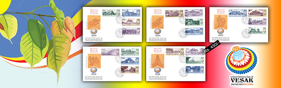
The Philatelic Bureau of the Department of Posts has issued twenty numbers of new postage stamps in the denomination of Rs. 15.00 each depicting remarkable Buddhist places of worship in twenty countries to commemorate the United Nations Vesak Festival of 2561 BE, on 12th May, 2017.
"Buddhist Teachings for Social Justice and Sustainable World Peace" will be the theme of United Nations Day of Vesak celebrations this year.
| Date of Issue: | 12th May, 2017 |
| Denomination: | Rs. 15.00 each |
| Designer of the first day covers : | Mr. Pulasthi Ediriweera |
| Prestige book layout : | Mr. P. Isuru Chaturanga |
| Stamp Size : | 60mm x25mm |
| Format : | Horizontal |
| Sheet Composition: | 20 stamps per sheet |
Stamp no. |
Catalogue No. |
Designer of the stamp |
1-20 |
CSL 2226 |
JagathKosmodara |
2-20 |
CSL 2227 |
PrasadiniKumari |
3-20 |
CSL 2228 |
PulasthiEdiriweera |
4-20 |
CSL 2229 |
PulasthiEdiriweera |
5-20 |
CSL 2230 |
PrasadiniKumari |
6-20 |
CSL 2231 |
PulasthiEdiriweera |
7-20 |
CSL 2232 |
MevanFonseka |
8-20 |
CSL 2233 |
JagathKosmodara |
9-20 |
CSL 2234 |
RuwanIndrajithUpasena |
10-20 |
CSL 2235 |
GayaniGunathunga |
11-20 |
CSL 2236 |
GayaniGunathunga |
12-20 |
CSL 2237 |
RuwanIndrajithUpasena |
13-20 |
CSL 2238 |
MevanFonseka |
14-20 |
CSL 2239 |
JagathKosmodara |
15-20 |
CSL 2240 |
GayaniGunathunga |
16-20 |
CSL 2241 |
JagathKosmodara |
17-20 |
CSL 2242 |
MevanFonseka |
18-20 |
CSL 2243 |
MevanFonseka |
19-20 |
CSL 2244 |
RuwanIndrajithUpasena |
20-20 |
CSL 2245 |
PrasadiniKumari |

MesAynak is a site 40 km southeast of Kabul, Afghanistan, located in a barren region of Logar Province. The site contains Afghanistan's largest copper deposit, as well as the remains of an ancient settlement with over 400 Buddha statues, stupas and a 40 ha (100 acres) monastery complex. It is also considered a major transit route for insurgents coming from Pakistan. Archaeologists are only beginning to find remnants of an older 5,000-year-old Bronze Age site beneath the Buddhist level, including an ancient copper smelter.
The site of MesAynak possesses a vast complex of Buddhist monasteries, homes, and market areas. The site contains artifacts recovered from the Bronze Age, and some of the artifacts recovered have dated back over three thousand years. The site's orientation on the Silk Road has yielded a mixture of elements from Iran, China and India. The wealth of MesAynak’s residents has been well represented in the site's far-reaching size and well guarded perimeter. Afghanistan’s eagerness to unearth the copper below the site is leading to the site's destruction rather than its preservation. Archaeologists have photographed the site and the relics excavated.
The Buddhist ruins were scheduled to be destroyed at the end of July 2012, but for several reasons, including political instability, this has been delayed. As the name suggests, the presence of copper at MesAynak has been known about for some time, while the site's archaeological wealth has been known about since exploration by Russian and Afghan geologists in 1973-4. The earliest Buddhist remains date from the Kushan Gandhara era, although these gradually gave way to T'ang Chinese and Uyghur influences. MesAynak was at the peak of its prosperity between the fifth and seventh century AD. A period of slow decline began in the eighth century, and the settlement was finally abandoned 200 years later.
Archaeologists believe that MesAynak is a major historical heritage site. It has been called "one of the most important points along the Silk Road" by French archaeologist, Philippe Marquis. There are thought to be 19 separate archaeological sites in the valley including two small forts, a citadel, four fortified monasteries, several Buddhist stupas and a Zoroastrian fire temple, as well as ancient copper workings, smelting workshops, a mint, and miners habitations. In addition to the Buddhist monasteries and other structures from the Buddhist era that have already been identified, MesAynak also holds the remains of prior civilizations likely going back as far as the 3rd century BC. Historians are particularly excited by the prospect of learning more about the early science of metallurgy and mining by exploring this site. It is known to contain coins, glass, and the tools for making these, going back thousands of years. Archaeologists have already unearthed manuscripts that may provide evidence regarding the presence of Alexander the Great's troops.
All of this historical material is in imminent danger of destruction by the mining endeavor. In response to negative reports in the press comparing the Chinese mining company to those who destroyed the Buddhas of Bamiyan, a plan for minimal archaeological excavation was put in place. This plan still foresees the destruction of the site and everything still buried beneath it, but it does allow for the removal of whatever artifacts can be carried away by a small archaeological team led by DAFA, the French archaeological mission to Afghanistan.
Geographically located to the north-west of Bangladesh in the district of Naogaon, the heart-land of ancient “Varendra”, close to the village of Paharpur the extensive ruins of the Buddhist monastic complex are the most spectacular and important pre-Islamic monument in Bangladesh.
The first builder of the monastery was DharmapalaVikramshila (770-810AD), the king of Varendri-Magadha, as inscribed on a clay seal discovered in the monastery compound. The plan of the monastery can be described as a large square quadrangle measuring approximately 920 feet, with the main entrance, an elaborate structure, on the northern side. The outer walls of the monastery are formed by rows of cells that face inwards toward the main shrine in the centre of the courtyard. In the last building phases of the Monastery these cells, which formed the outer wall, totalled 177. The main central shrine has a cruciform ground plan and a terraced superstructure that rises in three terraces above ground level to a height of about 70 feet. The upper level is a massive rectangular central block which forms the central brick shaft. The intermediate terrace is a wide circumambulatory path which passes four main chapels or mandapas architectural plan, it is in fact a simple cruciform that has been elaborated with a series of projections at the re-entrants, a form that is copied at all levels on the main shrine. At the intermediate level there were originally two bands of terracotta plaques running around the full perimeter of the shrine, out of which half are still preserved in situ.
The ground level today is 3 feet above the original pradakshinapatha or main circumambulatory path, below the base of the lowest band of terracotta plaques. Archaeological excavations have revealed a 15 feet pathway that follows an elaborated cruciform shape, a feature that can be discerned from the foundations of the outer wall that enclose the pathway and that still exist. At the base of the shrine, there are over 60 stone sculptures which depict a variety of Hindu divinities. The main entrance to the monastery was through a fortified gate on the northern access to the central temple. The majority of the ancillary buildings, such as the kitchen and the refectory, are located in the south-east corner, but there were also a few structures to be found in the north-east corner.
Epigraphic records testify that the cultural and religious life of this great Vihara, were closely linked with the contemporary Buddhist centres of fame and history at Bodh Gaya and Nalanda, many Buddhist treatises were completed at Paharpur, a centre where the Vajrayana trend of Mahayana Buddhism was practiced.
Today, Paharpur is the most spectacular and magnificent monument in Bangladesh and the second largest single Buddhist monastery on south of the Himalayas.
Paro Taktsang (also known as the Taktsang Palphug Monastery and the Tiger's Nest), is a prominent Himalayan Buddhist sacred site and the temple complex is located in the cliffside of the upper Paro valley in Bhutan.
A temple complex was first built in 1692, around the Taktsang SengeSamdup cave where Guru Padmasambhava is said to have meditated for three years, three months, three weeks, three days and three hours in the 8th century. Padmasambhava is credited with introducing Buddhism to Bhutan and is the tutelary deity of the country. Today, Paro Taktsang is the best known of the thirteen taktsang or "tiger lair" caves in which he meditated.
The temple devoted to Padmasambhava (also known as "the Temple of the Guru with Eight Names") is an elegant structure built around the cave in 1692 by Gyalse Tenzin Rabgye; and has become the cultural icon of Bhutan. A popular festival, known as the Tsechu, held in honor of Padmasambhava, is celebrated in the Paro valley sometime during March or April.
According to the legend related to this Taktsang which literally means "Tiger's lair", it is believed that Padmasambhava (Guru Rinpoche) flew to this location from Tibet on the back of a tigress from Khenpajong. This place was consecrated to tame the Tiger demon.
An alternative legend holds that a former wife of an emperor, known as YesheTsogyal, willingly became a disciple of Guru Rinpoche (Padmasambahva) in Tibet. She transformed herself into a tigress and carried the Guru on her back from Tibet to the present location of the Taktsang in Bhutan. In one of the caves here, the Guru then performed meditation and emerged in eight incarnated forms (manifestations) and the place became holy. Subsequently, the place came to be known as the “Tiger's Nest”.
Angkor, in Cambodia’s northern province of Siem Reap, is one of the most important archaeological sites of Southeast Asia. It extends over approximately 400 square kilometres and consists of scores of temples, hydraulic structures (basins, dykes, reservoirs, canals) as well as communication routes. For several centuries Angkor, was the centre of the Khmer Kingdom. With impressive monuments, several different ancient urban plans and large water reservoirs, the site is a unique concentration of features testifying to an exceptional civilization. Temples such as Angkor Wat, the Bayon, Preah Khan and Ta Prohm, exemplars of Khmer architecture, are closely linked to their geographical context as well as being imbued with symbolic significance. The architecture and layout of the successive capitals bear witness to a high level of social order and ranking within the Khmer Empire. Angkor is therefore a major site exemplifying cultural, religious and symbolic values, as well as containing high architectural, archaeological and artistic significance.
The park is inhabited, and many villages, some of whom the ancestors are dating back to the Angkor period are scattered throughout the park. The population practices agriculture and more specifically rice cultivation.
The Yungang Buddhist Rock-Cut Temple was constructed from mid-5thCentury to early-6th Century CE. This complex has over 252 Rock-cut caves and niches and 51,000 statues within an area of 18,000 square meters. The Yungang Rock-cut Temple represent the outstanding achievement of Buddhist Rock-cut cave art in China. The Five Caves created by Tan Yao are a classical masterpiece of the first peak of Chinese Buddhist art, with a strict unity of layout and design. The will of the State is reflected in Buddhist belief in China during the Northern Wei Dynasty since the Rock-cut Temple was built with Imperial instructions. While influenced by Buddhist cave art from South and Central Asia, Yungang Rock-cut Temple have also interpreted the Buddhist cave art with distinctive Chinese character and local spirit. As a result, Yungang Rock-cut Temple has played an important role among early Buddhist Rock-cut Temples and had a far-reaching impact on Buddhist Rock-cut Temple art in China and East Asia.
On a hill overlooking the plain and about 40 km from Bhopal, the site of Sanchi comprises a group of Buddhist monuments (monolithic pillars, palaces, temples and monasteries) all in different states of conservation most of which date back to the 2nd and 1st centuries B.C. It is the oldest Buddhist sanctuary in existence and was a major Buddhist centre in India until the 12th century A.D.
Unique in India because of its age and quality, the group of Buddhist stupas, temples and monasteries at Sanchi is one of the oldest Buddhist sanctuary in existence. These monuments record the genesis and efflorescence of Buddhist art and architecture over a period of 1,300 years from the 3rd century BC to the 12th century CE, thereby spanning almost the entire classical Buddhist period in India. Surprisingly, Sanchi was not hallowed by any incident in Buddha’s life. The only early reference to Sanchi occurs in the chronicle of Sri Lanka, Mahavamsa and Dipavamsa (c. 3rd-4thcentury CE). Sanchi was discovered in 1818 after being abandoned for nearly 600 years, and gradually the archaeological site was explored, excavated and conserved.
The religious establishment at Sanchi was founded by the Mauryan emperor Asoka (c. 272-237 BC). Here, he built a Maha Stupa and erected a monolithic pillar and a monastery atop the hill at the insistence of his queen, who was from Vidisha, located 10 km from Sanchi. With its serene environment and seclusion, Sanchi ensured a proper atmosphere for meditation and fulfilled all the conditions required for an ideal Buddhist monastic life. Several edifices were raised at Sanchi and its surrounding hills during the Sunga times. The Asokan Stupa was enlarged and covered with stone veneering, and balustrades along with a staircase and harmika were added. The reconstruction of Temple 40 and the erection of Stupa 2 and Stupa 3 also appear to date to about the same period. In the 1st century BC, the Andhra-Satavahanas, who had extended their influence over eastern Malwa, created the elaborately carved gateways to Stupa 1. From the 2nd to 4th centuries CE, Sanchi and Vidisha were under the Kushanas and Kshatrapas and were subsequently passed on to the Guptas. A number of temples were built and sculptures added at Sanchi and Udayagiri, near Vidisha, during this period. Shrines and monasteries were also constructed at this site during the 7th and 10th centuries CE.
The Borobudur Temple Compounds is one of the greatest Buddhist monuments in the world, and was built in the 8th and 9th centuries AD during the reign of the Syailendra Dynasty. The monument is located in the Kedu Valley, in the southern part of Central Java, at the centre of the island of Java, Indonesia.
The main temple is a stupa built in three tiers around a hill which was a natural centre: a pyramidal base with five concentric square terraces, the trunk of a cone with three circular platforms and, at the top, a monumental stupa. The walls and balustrades are decorated with fine low reliefs, covering a total surface area of 2,520 m2. Around the circular platforms are 72 openwork stupas, each containing a statue of the Buddha.
The vertical division of Borobudur Temple into base, body, and superstructure perfectly accords with the conception of the Universe in Buddhist cosmology. It is believed that the universe is divided into three superimposing spheres, kamadhatu, rupadhatu, and arupadhatu, representing respectively the sphere of desires where we are bound to our desires, the sphere of forms where we abandon our desires but are still bound to name and form, and the sphere of formlessness where there is no longer either name or form. At Borobudur Temple, the kamadhatu is represented by the base, the rupadhatu by the five square terraces, and the arupadhatu by the three circular platforms as well as the big stupa. The whole structure shows a unique blending of the very central ideas of ancestor worship, related to the idea of a terraced mountain, combined with the Buddhist concept of attaining Nirvana.
The Temple should also be seen as an outstanding dynastic monument of the Syailendra Dynasty that ruled Java for around five centuries until the 10th century. The Borobudur Temple Compounds consists of three monuments: namely the Borobudur Temple and two smaller temples situatued to the east on a straight axis to Borobudur. The two temples are Mendut Temple, whose depiction of Buddha is represented by a formidable monolith accompanied by two Bodhisattvas, and Pawon Temple, a smaller temple whose inner space does not reveal which deity might have been the object of worship. Those three monuments represent phases in the attainment of Nirvana.
The temple was used as a Buddhist temple from its construction until sometime between the 10th and 15th centuries when it was abandoned. Since its re-discovery in the 19th century and restoration in the 20th century, it has been brought back into a Buddhist archaeological site.
The Buddhist Monuments in the Horyu-ji is in the Nara Prefecture. The property consists of forty-eight ancient wooden structures located at the two temples sites, twenty-one at Horyu-ji temple and Hokki-ji temple. The Horyu-ji temple covers an area of 14.6 hectares and the smaller Hokki-ji Temple 0.7 hectares. The Buddhist Monuments in the Horyu-ji Area are the earliest Buddhist monuments in Japan, dating from shortly after the introduction of Buddhism to the country, and had a profound influence on subsequent religious architecture.
Eleven structures on the temple sites date from the late-7th or 8th century making them some of the oldest surviving wooden buildings in the world. Although a fire destroyed the original Horyu-ji buildings in 670, structural remains survive below ground in the precinct known as WakakusaGaran to the south-east of the later West Temple (Sai-in). Rebuilding commenced almost immediately and continued into the early years of the 8th century.
The structures are based on the Chinese bay system, a modified version of post-and-lintel construction with intricate bracketing designed to transfer the weight of the heavy tiled roof down to the massive wooden supporting columns. They are especially noteworthy for the skillful use of entasis on the columns and their cloud-shaped brackets.
These masterpieces of wooden architecture are important not only for the history of art, since they illustrate the adaptation of Chinese Buddhist architecture and layout to Japanese culture, but also for the history of religion, since their construction coincided with the introduction of Buddhism to Japan from China by way of the Korean peninsula. From its foundation Horyu-ji always enjoyed the protection of the imperial family. In addition, the cult of Prince Shotoku, which flourished after the 12th century, attracted many pilgrims, and as a result Horyu-ji was always immaculately maintained and conserved.
LuangPrabang is located in northern Laos at the heart of a mountainous region. The town is built on a peninsula formed by the Mekong and the Nam Khan River. Mountain ranges (in particular the PhouThao and PhouNangmountains) encircle the city in lush greenery.
Many legends are associated with the creation of the city, including one that recounts that Buddha would have smiled when he rested there during his travels, prophesying that it would one day be the site of a rich and powerful city. Known as MuangSua, then Xieng Thong, from the 14th to the 16th century the town became the capital of the powerful kingdom of Lane Xang (Kingdom of a Million Elephants), whose wealth and influence were related to its strategic location on the Silk Route. The city was also the centre of Buddhism in the region. LuangPrabang takes its name from a statue of Buddha, the Prabang, offered by Cambodia.
After the establishment of the French Protectorate in 1893, following a period of turmoil during which the country was divided into three independent kingdoms, LuangPrabang once again became the royal and religious capital during the reign of King SisavangVong. It played this role until Vientiane became the administrative capital in 1946.
LuangPrabang is exceptional for both its rich architectural and artistic heritage that reflects the fusion of Lao traditional urban architecture with that of the colonial era. Its remarkably well-preserved townscape reflects the alliance of these two distinct cultural traditions.
The political and religious centre of LuangPrabang is the peninsula, with its royal and noble residences and religious foundations. The traditional urban fabric of the old villages, each with its temple, was preserved by later constructions. The colonial urban morphology, including the network of streets, overlapped harmoniously with the previous model. Formerly the town limits were defined by defensive walls.
The KekLok Si Temple is a Buddhist temple situated in Air Itam in Penang facing the sea and commanding an impressive view, and is one of the best known temples on the island. It is said to be the largest Buddhist temple in Malaysia. It is also an important pilgrimage centre for Buddhists from Hong Kong, the Philippines, Singapore and other countries in Southeast Asia. This entire complex of temples was built over a period from 1890 to 1930, an inspirational initiative of Beow Lean, the Abbot. The main draw in the complex is the striking seven-storey Pagoda of Rama VI (Pagoda of Ten Thousand Buddhas) with 10,000 alabaster and bronze statues of Buddha, and the 30.2 metres (99 ft) tall bronze statue of Kuan Yin, the Goddess of Mercy.
Mahayana Buddhism, Theravada Buddhism and traditional Chinese rituals blend into a harmonious whole, both in the temple architecture and artwork as well as in the daily activities of worshippers. The temple is heavily commercialized with shops at every level and inside the main temple complexes selling all religious paraphernalia.
The construction of the temple began in 1890 and completed in 1905. It was inspired by Beow Lean, the chief monk of the Goddess of Mercy Temple at Pitt Street in 1887; he had served earlier in the Kushan Abbey in Fujian in China. The site chosen by Beow, a spiritual location in the hills of Ayer Itam, facing the sea, was named "Crane Mountain". It was established as a branch of the Buddhist Vatican in Drum Mountain in Foochow in Hokkien province. Beow Lean was the first Abbot of the temple. The buildings of the temple complex were sponsored by five leading Chinese business people of Penang known as "Hakka tycoons". They were: Cheong FattTze, his cousin Chang Yu Nan, CheaChoon Seng, TyeKee Yoon, and Chung KengKooi. Collection of funds for building the temple was also facilitated by dedicating the structures and artefacts in the name of the temple's benefactors. The main hall, which was completed first, housed a shrine to Guanyin, in a recessed area where many other female goddesses called the Queen of Heaven, the Goddess of the Earth, and Goddess of Childbirth are housed; which is said to represent, on a miniature scale, the island of Potalaka where there is a large shrine dedicated to Guanyin in the China Sea. People compared this shrine to the Amitabha Buddha's Western Paradise and started calling it the "KekLok Si" ("Jile Si"). There are also many other shrine chambers, which have stately statues, all gilded, of the Buddhas, Bodhisattvas, saintly Lohans, guardian spirits, and Heavenly (or Diamond) Kings of Pure Land Buddhism.
The consular representative of China in Penang reported the grandeur of the temple to the Qing Government. Following this, the Guangxu Emperor invited Beow Lean to Beijing in 1904 and bestowed on him, 70,000 volumes (7,000 is also mentioned in some references) of the "psalms and other sacred works of Buddhism" and also presented him edicts anointing him as "dignity of the Chief Priest of Penang" and also declaring "the Chinese temple at Air Itam as the head of all Chinese temples in Penang". On the Abbot's return to Penang, a royal procession, carrying the edict in a rattan chair and the scriptures in pony driven carts, was organised leading to the temple complex. Prominent Chinese dignitaries of Penang in their royal mandarin attire accompanied the Abbot in the procession.
In 1930, the seven storey main pagoda of the temple or the Pagoda of "Ban Po Thar", the Ten Thousand Buddhas, a 30 metres (98 ft) high structure, was completed. This pagoda combines a Chinese octagonal base with a middle tier of Thai design, and a Burmese crown (spiral dome); reflecting the temple's amalgam of both Mahayana and Theravada Buddhism. It represents syncretism of the ethnic and religious diversity in the country. There is a large statue of Buddha donated by King Bhumibol of Thailand diefied here.King Rama VI of Thailand laid the foundation for the pagoda and it is hence also named as Rama Pagoda.
In 2002, a 30.2-metre (99 ft) bronze statue of Guanyin, the Goddess of Mercy, was completed and opened to the public. It replaced the previous white plaster Kuan Yin statue which was damaged due to a fire a few years earlier. The bronze statue is located on the hillside above the pagoda. The statue is complemented with a 60.9 metres (200 ft) three-tiered roof pavilion (with 16 columns made of bronze supporting the pavilion), which was completed in 2009. It is the tallest Guanyin statue in the world. One hundred statues of the goddess Kuan Yin, each of 2 metres (6 ft 7 in) height, are set around the main statue of the goddess. However, its height was restricted to avoid its shadow falling on the Penang State Mosque. This shrine also has other 10,000 statues of Buddha, apart from a statue of 12 Zodiac Animal Signs of the Chinese Calendar.
The temple complex has a large hydraulically operated bell, which tolls with a high pitch at frequent intervals. Wood and stone carvings are profusely seen in the temple. In front of each deity there is a cushion, impressive scrolls, and candles set in very attractive suspended lamps, and with a large number of priests in attendance.
The Gandantegchinlen Monastery is a Chinese-style Tibetan Buddhist monastery in the Mongolian capital of Ulaanbaatar that has been restored and revitalized since 1990. The Tibetan name translates to the "Great Place of Complete Joy". It currently has over 150 monks in residence. It features a 26.5-meter-high statue of Avalokiteśvara. It came under state protection in 1994.
The monastery was constructed by order of the 5th JebtsundambaKhutuktu in 1809. The first temple was the GungaachoilinDatsan. Only one wooden pillar remains from this temple. In 1838, the Gandantegchenlin Temple was built along with the private residence of the JebtsundambaKhutuktu. The 13th Dalai Lama stayed in the residence in 1904. In 1840, the Vajradhara Temple was built. In 1869, the Zuu Temple was built. In 1913, the tall Avalokiteśvara temple was built. In 1925, the temple for keeping the remains of the 8th JebtsundambaKhutuktu was built. It is now the monastery library.
In the 1930s, the Communist government of Mongolia, under the leadership of Khorloogiin Choibalsan and under the influence of Joseph Stalin, destroyed all but a few monasteries and killed more than 15,000 lamas.
GandantegchinlenKhiid monastery, having escaped this mass destruction, was closed in 1938, but then reopened in 1944 and was allowed to continue as the only functioning Buddhist monastery, under a skeleton staff, as a token homage to traditional Mongolian culture and religion. With the end of Marxism in Mongolia in 1990, restrictions on worship were lifted.
Bagan (formerly Pagan) is an ancient city located in the Mandalay Region of Myanmar. From the 9th to 13th centuries, the city was the capital of the Kingdom of Pagan, the first kingdom to unify the regions that would later constitute modern Myanmar. During the kingdom's height between the 11th and 13th centuries, over 10,000 Buddhist temples, pagodas and monasteries were constructed in the Bagan plains alone, of which the remains of over 2200 temples and pagodas still survive to the present day.
The Bagan Archaeological Zone is a main draw for the country's nascent tourism industry. It is seen by many as equal in attraction to Angkor Wat in Cambodia. Bagan's prosperous economy built over 10,000 temples between the 11th and 13th centuries. According to the Burmese chronicles, Bagan was founded in the second century AD, and fortified in 849 AD by King Pyinbya, 34th successor of the founder of early Bagan. Mainstream scholarship however holds that Bagan was founded in the mid-to-late 9th century by the Mranma (Burmans), who had recently entered the Irrawaddy valley from the Nanzhao Kingdom. It was among several competing Pyu city-states until the late 10th century when the Burman settlement grew in authority and grandeur.
From 1044 to 1287, Bagan was the capital as well as the political, economic and cultural nerve center of the Pagan Empire. Over the course of 250 years, Bagan's rulers and their wealthy subjects constructed over 10,000 religious monuments (approximately 1000 stupas, 10,000 small temples and 3000 monasteries) in an area of 104 square kilometres (40 sq mi) in the Bagan plains. The prosperous city grew in size and grandeur, and became a cosmopolitan center for religious and secular studies, specializing in Pali scholarship in grammar and philosophical-psychological (abhidhamma) studies as well as works in a variety of languages on prosody, phonology, grammar, astrology, alchemy, medicine, and legal studies. The city attracted monks and students from as far as India, Sri Lanka and the Khmer Empire.
The culture of Bagan was dominated by religion. The religion of Bagan was fluid, syncretic and by later standards, unorthodox. It was largely a continuation of religious trends in the Pyu era where Theravada Buddhism co-existed with Mahayana Buddhism, Tantric Buddhism, various Hindu (Saivite, and Vaishana) schools as well as native animist (nat) traditions. While the royal patronage of Theravada Buddhism since the mid-11th century had enabled the Buddhist school to gradually gain primacy, other traditions continued to thrive throughout the Pagan period to degrees later unseen.
The Pagan Empire collapsed in 1287 due to repeated Mongol invasions (1277–1301). Recent research shows that Mongol armies may not have reached Bagan itself, and that even if they did, the damage they inflicted was probably minimal. However, the damage had already been done. The city, once home to some 50,000 to 200,000 people, had been reduced to a small town, never to regain its preeminence. The city formally ceased to be the capital of Burma in December 1297 when the Myinsaing Kingdom became the new power in Upper Burma.
Bagan survived into the 15th century as a human settlement, and as a pilgrimage destination throughout the imperial period. A smaller number of "new and impressive" religious monuments still went up to the mid-15th century but afterward, new temple constructions slowed to a trickle with fewer than 200 temples built between the 15th and 20th centuries. The old capital remained a pilgrimage destination but pilgrimage was focused only on "a score or so" most prominent temples out of the thousands such as the Ananda, the Shwezigon, the Sulamani, the Htilominlo, the Dhammayazika, and a few other temples along an ancient road. The rest—thousands of less famous, out-of-the-way temples—fell into disrepair, and most did not survive the test of time.
For the few dozen temples that were regularly patronized, the continued patronage meant regular upkeep as well as architectural additions donated by the devotees. Many temples were repainted with new frescoes on top of their original Pagan era ones, or fitted with new Buddha statutes. Then came a series of state-sponsored "systematic" renovations in the Konbaung period (1752–1885), which by and large were not true to the original designs—some finished with "a rude plastered surface, scratched without taste, art or result". The interiors of some temples were also whitewashed, such as the Thatbyinnyu and the Ananda. Many painted inscriptions and even murals were added in this period. The original Bupaya seen here in 1868 was completely destroyed by the 1975 earthquake. A new pagoda in the original shape, but gilded, has been rebuilt.
Bagan, located in an active earthquake zone, had suffered from many earthquakes over the ages, with over 400 recorded earthquakes between 1904 and 1975. A major earthquake occurred on 8 July 1975, reaching 8 MM in Bagan and Myinkaba, and 7 MM in Nyaung-U. The quake damaged many temples, in many cases, such as the Bupaya, severely and irreparably.
On 24 August 2016, a major earthquake hit central Burma and again did major damage in Bagan; this time almost 400 temples were destroyed. The Sulamani and MyaukGuni (North Guni) were severely damaged. The Bagan Archaeological Department has started a survey and reconstruction effort with the help of UNESCO experts. Visitors are prohibited from entering 33 damaged temples.
The Lord Buddha was born in 623 BC in the sacred area of Lumbini located in the Terai plains of southern Nepal, testified by the inscription on the pillar erected by the Mauryan Emperor Asoka in 249 BC. Lumbini is one of the holiest places of one of the world's great religions, and its remains contain important evidence about the nature of Buddhist pilgrimage centres from as early as the 3rd century BC.
The complex of structures within the archaeological conservation area includes the Shakya Tank; the remains within the Maya Devi Temple consisting of brick structures in a cross-wall system dating from the 3rd century BC to the present century and the sandstone Ashoka pillar with its Pali inscription in Brahmi script. Additionally there are the excavated remains of Buddhist viharas (monasteries) of the 3rd century BC to the 5th century AD and the remains of Buddhist stupas (memorial shrines) from the 3rd century BC to the 15th century AD. The site is now being developed as a Buddhist pilgrimage centre, where the archaeological remains associated with the birth of the Lord Buddha form a central feature.
Taxila, located in the Rawalpindi district of Pakistan’s Punjab province, is a vast serial site that includes a Mesolithic cave and the archaeological remains of four early settlement sites, Buddhist monasteries, and a Muslim mosque and madrassa. Situated strategically on a branch of the Silk Road that linked China to the West, Taxila reached its apogee between the 1st and 5th centuries. It is now one of the most important archaeological sites in Asia. The ruins of the four settlement sites at Taxila reveal the pattern of urban evolution on the Indian subcontinent through more than five centuries. One of these sites, the Bihr mound, is associated with the historic event of the triumphant entry of Alexander the Great into Taxila. The archaeological sites of Saraikala, Bhir, Sirkap, and Sirsukh are collectively of unique importance in illustrating the evolution of urban settlement on the Indian subcontinent. The prehistoric mound of Saraikala represents the earliest settlement of Taxila, with evidence of Neolithic, Bronze Age, and Iron Age occupation. The Bhir mound is the earliest historic city of Taxila, and was probably founded in the 6th century BC by the Achaemenians. Its stone walls, house foundations, and winding streets represent the earliest forms of urbanization on the subcontinent. Bihr is also associated with Alexander the Great’s triumphant entry into Taxila in 326 BC. Sirkap was a fortified city founded during the mid-2nd century BC. The many private houses, stupas, and temples were laid out on the Hellenistic grid system and show the strong Western classical influence on local architecture. The city was destroyed in the 1st century by the Kushans, a Central Asian tribe. To the north, excavations of the ruins of the Kushan city of Sirsukh have brought to light an irregular rectangle of walls in ashlar masonry, with rounded bastions. These walls attest to the early influence of Central Asian architectural forms on those of the subcontinent.
The Taxila serial site also includes Khanpur cave, which has produced stratified microlithic tools of the Mesolithic period, and a number of Buddhist monasteries and stupas of various periods. Buddhist monuments erected throughout the Taxila valley transformed it into a religious heartland and a destination for pilgrims from as far afield as Central Asia and China. The Buddhist archaeological sites at Taxila include the Dharmarajika complex and stupa, the KhaderMohra grouping, the Kalawan grouping, the Giri monasteries, the Kunala stupa and monastery, the Jandial complex, the Lalchack and the Badalpur stupa remains and monasteries, the MohraMoradu monastic remains, the Pipplian and the Jaulian remains, and the Bahalar stupa and remains. The Giri complex also includes the remains of a three-domed Muslim mosque, ziarat (tomb), and madrassa (school) of the medieval period.
Ivolginsky datsan is the Buddhist Temple located in Buryatia, Russia, 23 km from Ulan Ude, near VerkhnyayaIvolga village.
The datsan was opened in 1945 as the only Buddhist spiritual centre of the USSR. In the course of time the little "Khambin'ssume" changed into the Monastic centre with a residence of Pandido Khambo lama, the leader of all Russian Lamas.
It was the residence of the Central Spiritual Board of Buddhists of the USSR and later of the Buddhist Traditional Sangha of Russia, as well as that of PandidoKhambo lama, the head of the Russian Buddhists. The spiritual activity of the datsan is manifested in temple rites, medical practice, and a traditional system of Buddhist education. The Buddhist university "Dashi Choinkhorling" was opened in 1991 attached to the datsan.
Unique samples of old Buryat art, as thangkas, sculptures, ritual objects are gathered and preserved at the Ivolginskydatsan. Among the monastery's treasures there is a collection of old Buddhist manuscripts written in Tibetan language on natural silk, and a greenhouse with a sacred Bodhi tree.
As a cultural and religious monument, the Datsan is protected by the State. The Datsan Centre consists of such temples as Sockshin-dugan, Maidrin-sume, Devazhin and Sakhiusan-sume. There are also a library, a hotel, the Choyra (Faculty of Philosophy), Dashi Choinhorlin (building of the Buddhist University), Museum of Buryat Art, suburgans (stupas), some infrastructure buildings and lamas' houses.
Within the Datsan complex is the Korean style wooden EtigelKhambin temple which honors the 12th Khambo Lama whose body was recently exhumed.
In 1927, the 12th PanditoHambo Lama of the IvolginskyDatsan, Dashi-DorzhoItigelov, told his students and fellow monks to bury his body after his death and to check on it again in 30 years. According to the story, Itigelov then sat in the lotus position, began chanting the prayer of death, and died, mid-meditation. The monks followed Itigilov's directions, but when they exhumed his body 30 years later, they were amazed to find none of the usual signs of decay and decomposition. On the contrary, Itigilov looked as if he had been dead only a few hours, rather than three decades. Fearful of the Soviet response to their "miracle", the monks reburied Itigilov's body in an unmarked grave.
Itigelov's story was not forgotten over the years and on September 11, 2002 the body was finally exhumed and transferred to IvolginskyDatsan where it was closely examined by monks and by scientists and pathologists. The official statement was issued about the body – very well preserved, without any signs of decay, whole muscles and inner tissue, soft joints and skin. The interesting thing is that the body was never embalmed or mummified.
The Kong Meng San PhorKark See Monastery, is a Buddhist temple located in Bishan, Singapore. Built by Zhuan Dao in the early 20th century to propagate Buddhism and to provide lodging for monks, this monastery is the largest Buddhist temple in Singapore.
Between 1920 and 1921, the PhorKark See Monastery was built on a plot of land in Thomson Road donated by Tay Woo Seng, a Chinese businessmen. It was the first traditional Chinese forest monastery to be built in Singapore. Since PhorKark See Monastery is situated at Kong Meng San ("Bright Hill", formerly "Hai Nan Mountain"), it has come to be known as "Kong Meng San PhorKark See Monastery". The original temple consisted of a two-storey building, a shrine room, a visitors' room and living quarters. The Monastery expanded steadily over time as philanthropists like Aw Boon Haw and Aw Boon Par donated funds to the monastery for its expansion.
In 1947, Hong Choon became the monastery's abbot. Under his leadership, the monastery's complex expanded from two shrine halls to include the Pagoda of 10,000 Buddhas and prayer halls that are as large as ten football fields. He also progressively developed and expanded the monastery with his followers into the largest and most majestic place of practice in Singapore.
In 1980, the temple began to build Evergreen Bright Hill Home, which opened in 1983, with the donation of S$5.3 million from Hong Choon's followers, He Hui Zhong's family's company and focuses on a single mother who gives her son inspirational notes.
The JanggyeongPanjeon in the Temple of Haeinsa, on the slopes of Mount Gayasan, is home to the Tripitaka Koreana, or the Korean Tripitaka, the most complete collection of Buddhist texts, laws and treaties extant, engraved on approximately 80,000 woodblocks between 1237 and 1248. The Haeinsa Tripitaka woodblocks were carved in an appeal to the authority of the Buddha in the defense of Korea against the Mongol invasions. They are recognized by Buddhist scholars around the world for their outstanding accuracy and superior quality. The woodblocks are also valuable for the delicate carvings of the Chinese characters, so regular as to suggest that they are the work of a single hand.
The JanggyeongPanjeon depositories comprise two long and two smaller buildings, which are arranged in a rectangle around a courtyard. As the most important buildings in the Haeinsa Temple complex, they are located at a higher level than the hall housing the main Buddha of the complex. Constructed in the 15th century in the traditional style of the early Joseon period, their design is characterized by its simplicity of detailing and harmony of layout, size, balance and rhythm.
The four buildings are considered to be unique both in terms of their antiquity with respect to this specialized type of structure, and for the remarkably effective conservation solutions that were employed in their design to protect the woodblocks from deterioration, while providing for easy access and storage. They were specially designed to provide natural ventilation and to modulate temperature and humidity, adapted to climatic conditions, thus preserving the woodblocks for some 500 years from rodent and insect infestation. The Haeinsa Temple complex is a famous destination for pilgrimages, not only among Korean Buddhists, but Buddhists and scholars from all over the world.
The Lankatilaka temple history runs back to the Gampola Kingdom era. King Buwanekabahu IV has built this temple in 1344 AD. The King's Chief Ministers Senalankadhikara was entrusted to carry out the construction work of this temple. The South Indian architect SthapatiRayar has designed this with a blend of Sinhalese architecture of Polonnaruwa period and of Dravidian and Indo Chinese style is the opinion of late Professor Paranavitana. Considered to be a Gedige type of Polonnaruwa architecture, this temple which was of four stories earlier is constructed on the uneven surface of the rock with a granite based foundation. The plan of the temple protrudes to the four sides like of a cross. What is seen today is the Ground Floor and part of the First Floor of the earlier temple though the temple seems to have three stories. This temple is an example for the Buddha and God worship prevailed during Gampola era. Gods Vishnu, Saman, Vibhishana, Ganapathi, Skandhakumara and Kumara Bandara had been worshipped here.
On the vihara premises is the Temple Building, the Dagoba or the Chetiya and the Bo tree. A Buddha Siripatula or the large stone image of the Lord Buddha's footprint can be seen near the Bodhigharaya.
The rock inscriptions found in the temple is cut into the solid rock covering a large area. Both Sinhala and Tamil inscriptioned sections could be found here describing the facilities provided to the Temple and land gifted by the kings.
The vihara is entirely located on the rock surface and according to the Lankatilaka Copper plaque, the temple was built as a four storied building reaching a height of eighty feet. The stone foundation was built on to the uneven rock surface and brick was made used to build the structure on that. The thick outer walls are well designed with arches and sculptures which makes the Lankatilaka temple a unique architectural features of the fourteenth century design concepts which includes Gandharva and Gaja Lakshmi arts also.
Approach to the Buddha Image house is from the vihara facing the Eastern side which is the approach from the flight of stone steps. There is a Moonstone or a Sandakadapahana at the steps leading into the temple. Two Balustrades or Korawakgalas of Gajasinha design is flanked by the sides of the steps leading to arched doorway. The outer Dragon arch or the Makara Torana has unique features making it very special. Inside the arched doorway, paintings of two Lion figures can be seen. The Guardian figures found here has the Tivanka characteristics.
Inside the image house is a Seated Buddha statue with a Makara Torana above the image. The concept of Bodhi is depicted here by the arrangement of tree and flower design. The paintings from SuvisiVivarana or the lives of the twenty four previous Buddha's are painted in the surrounding walls of the image house.
Situated in the lower northern region of present-day Thailand, the Historic Town of Sukhothai and Associated Historic Towns is a serial property consisting of three physically closely related ancient towns. The total property area is 11,852 ha., comprising Sukhothai 7,000 ha., Si Satchanalai 4,514 ha., and KamphaengPhet 338 ha. Sukhothai was the political and administrative capital of the first Kingdom of Siam in the 13th and 15th centuries. Si Satchanalai was the spiritual center of the kingdom and the site of numerous temples and Buddhist monasteries. Si Satchanalai was also the centre of the all-important ceramic export industry. The third town, KamphaengPhet, was located at the kingdom’s southern frontier and had important military functions in protecting the kingdom from foreign intruders as well as providing security for the kingdom’s extensive trading network. All three towns shared a common infrastructure to control water resources, and were linked by a major highway known as the ThanonPhraRuang after the king who constructed it.
Sukhothai, Si Satchanalai and KamphaengPhet all shared a common language and alphabet, a common administrative and legal system, and other features which leave no doubt as to their unity as a single political entity. All three towns also boasted a number of fine monuments and works of monumental sculpture, illustrating the beginning of Thai architecture and art known as the “Sukhothai style.”
Under royal patronage, Buddhism flourished and many impressive monasteries were constructed of brick covered with carved stucco, illustrating the idealized beauty and the superhuman characteristics (mahapurisalakkhana) of the Lord Buddha and His Teachings. It is from the remains of these religious monuments that today we best known and appreciate the achievements of the people of the Historic Town of Sukhothai and Associated Historic Towns.
The Kingdom of Sukhothai is accredited with the invention and development of many of the unique identifying characteristics of Siamese (Thai) culture, many of them attributed directly to the kingdom’s most famous and beloved King Ramkhamhaeng, who is considered the Founding Father of the Thai Nation.
The many examples of sculpture, wall paintings and decoration features found within the abandoned temple and monastery compounds are important in establishing the uniqueness and outstanding importance of the three towns. The art and architecture of Sukhothai, Si Satchanalai and KamphaengPhet have been extensively studied by art historians who have identified and catalogued its unique style, distinctive from Khmer and other earlier regional styles, and who consider the Buddhist monuments and their associated sculptures of the three towns to be masterpieces of artistic creation, giving the art style its own name: “Sukhothai style.” Stone inscriptions found at the sites provide evidence of the earliest examples of Thai writing and give a detailed account of the economy, religion, social organization and governance of the Sukhothai Kingdom.
In addition to being the place of pioneering achievements in architecture and art, language and writing, religion and law, the historic towns of the Sukhothai Kingdom were home to accomplished innovators in hydraulic engineering. They modified the landscape of the kingdom in such a way that water was dammed; reservoirs, ponds and canals were constructed; flooding controlled; and water was brought to serve a variety of agricultural, economic and ritual functions as well as to provide the towns’ inhabitants with water for their daily lives, avenues of communication, and protection in the form of city moats. From that day onwards until the Rattanakosin period, the kings of Thailand have been acknowledged for their ability to control the kingdom’s water.
The One Pillar Pagoda is a historic Buddhist temple in Hanoi, the capital of Vietnam. It is regarded alongside the Perfume Temple, as one of Vietnam's two most iconic temples. The temple was built by Emperor LY Thai Tong, who ruled from 1028 to 1054. According to the court records, LY Thai Tong was childless and dreamt that he met the bodhisattva Avalokiteshvara, who handed him a baby son while seated on a lotus flower. LY Thai Tong then married a peasant girl that he had met and she bore him a son. The emperor constructed the temple in gratitude for this in 1049, having been told by a monk named Thien Tue to build the temple, by erecting a pillar in the middle of a lotus pond, similar to the one he saw in the dream.
The temple was located in what was then the Tay Cam Garden in Thach Bao, VinhThuanThuận district in the capital Thang Long (now known as Hanoi). Before the pagoda was opened, prayers were held for the longevity of the monarch. During the Ly Dynasty era, the temple was the site of an annual royal ceremony on the occasion of Vesak, the birthday of Gautama Buddha. A Buddha-bathing ceremony was held annually by the monarch, and it attracted monks and laymen alike to the ceremony. The monarch would then free a bird, which was followed by the people.
The temple was renovated in 1105 by Emperor Ly Nhan Tong and a bell was cast and an installation was attempted in 1109. However, the bell, which was regarded as one of the four major capital works of Vietnam at the time, was much too large and heavy, and could not be installed. Since it could not be tolled while left on the ground, it was moved into the countryside and deposited in farmland adjacent to NhatTruTemple. This land was widely inhabited by turtles, so the bell came to be known as QuyDienchung, which means Bell of the Turtle Farmland. At the start of the 15th century, Vietnam was invaded and occupied by the Ming Dynasty. In 1426, the future Emperor Le Loi attacked and dispersed the Chinese forces, and while the Ming were in retreat and low on weapons, their commanding general ordered that the bell be smelted, so that the copper could be used for manufacturing weaponry.
http://www.unvesak2017.org/
http://whc.unesco.org
https://en.wikipedia.org
All rights received. All right to identify the Department of Posts as the Author and designer of this Bulleting has been asserted in accordance with the Copyright, Design and Patents Act 1988.No part to this publication may be reproduced, stored in or introduced into a retrieval system, or transmitted in any form or by and means (electronic, mechanical, photocopying, recording or otherwise) without the prior permission from the publisher. Any person who does and unauthorized act in relation to this publication may be liable to criminal prosecution and civil claims for damages.